Difference between revisions of "Assela Pathirana"
| (99 intermediate revisions by 2 users not shown) | |||
| Line 1: | Line 1: | ||
{{MainPageIntro}} | <!-- ''Average teachers become good ones by developing a strong passion for their act. Some, then become excellent ones by learning to control this passion, so that students get more space to learn''. --> | ||
----- | |||
{{MainPageIntro}} | |||
{| cellspacing="3" | {| cellspacing="3" | ||
|- valign="top" | |- valign="top" | ||
|width="45%" class="MainPageBG" style="border: 1px solid #F0F0FF; color: #000; background-color: #F0F0FF"| | |width="45%" class="MainPageBG" style="border: 1px solid #F0F0FF; color: #000; background-color: #F0F0FF"| | ||
<div style="padding: .4em .9em .9em" id="MainPageBox1"> | <div style="padding: .4em .9em .9em" id="MainPageBox1"> | ||
=== | ==[[Systems_thinking_for_Urban_Water_Systems|Systems thinking for Urban Water Systems]]== | ||
The | [[image:Systems_thinking_cartoon.jpg|thumb|400px|Systems thinking for water systems]] | ||
By Dr. [https://www.linkedin.com/in/mohanasundar-radhakrishnan-27757b1/?originalSubdomain=nl Mohanasundar Radhakrishnan] | |||
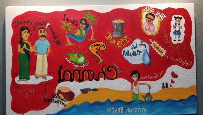
What is lost in an urban water system? The answer is obvious when you look at what flows in and out of these urban water networks, it is water. Some might say money and some might say energy. Yes, this is true but is not the whole truth. This training is about finding out what is lost from an urban water system by looking beyond water and looking in the urban systems to track the lost water and the other elements that are being lost. The training touches upon the three prime movers of the urban water utility, namely engineering, management and strategic planning. The place, proportion and play of this trinity in an urban water utility can be ascertained only by a thorough understanding of the urban system that is served by the water utility. This can shed light on what is actually gained and lost through urban water systems. | |||
We the engineers and managers of urban water utilities are trained to ascertain the problem, quantify the impact, find out why it happened and devise ways to minimise or eliminate the problem. Quantification has always been the guiding principle, the means and the end in this endeavour. The water balance methods in their original or modified form used all over the world follow this logic and has proved to be a success in estimating the quantity of non-revenue water and formulating actions to reduce the losses in terms of water and revenue. The training starts by introducing the conventional water loss assessment methods to the urban water engineers and managers; the various elements of a water distribution system comprising physical, conceptual and design aspects; and, water loss management measures. Understanding and analysing these engineering aspects of the water supply system would create a comfort zone from which the engineer can start the process of identifying and minimising losses. [[Systems_thinking_for_Urban_Water_Systems| Read more ...]] | |||
==Climate Security of Small Islands== | |||
Climate change presents unique challenges to Small Island Developing States (SIDS). The difficulties that all countries face in effectively coping with climate change impacts are exacerbated in SIDS because of their small geographical area, isolation and exposure. The associated development challenges from sea-level rise, altered rainfall patterns, and storm-surges threaten to reverse progress made towards the Millennium Development Goals now and in the future. The United Nations Development Programme (UNDP) provides on-the-ground support for small island and low-lying countries at the global, regional and national scales. - [https://sustainabledevelopment.un.org/index.php?page=view&type=400&nr=960&menu=1515 UNDP] | |||
The Maldives is already facing the brunt of Climate Change in the guise of water scarcity. Small atoll islands' water security depend on the important, but highly climate-sensitive, fresh water lenses. [[Climate and Water Security in the Maldives| Read more ...]] | |||
==Urban adaptation in rapidly growing cities need a paradigm shift== | |||
[[File:kuznet_framework_for_scgs.png|thumb|500px]] | |||
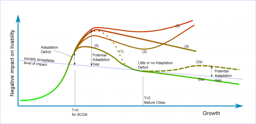
We have been working with rapid developing cities like [https://en.wikipedia.org/wiki/C%E1%BA%A7n_Th%C6%A1 Can Tho], vietnam ([https://scholar.google.nl/scholar?as_q=can+tho&as_epq=&as_oq=&as_eq=&as_occt=any&as_sauthors=pathirana&as_publication=&as_ylo=&as_yhi=&hl=en&as_sdt=0%2C5 see our work]) regarding adaptation. Here we intentionally use the term "Urban Adaptation" instead of more common "[https://en.wikipedia.org/wiki/Climate_change_adaptation Climate Adaptation]". The reason for that is, in cities like Can Tho (or any other Secondary City in the Global South - SCGS), climate change -- while being extremely relevant and important -- is only one of many pressures that they have to deal with in adaptation; Land-cover change, rapid population increase, increasing pollution are some others. | |||
In these two part series, we argue the importance of changing the way we look at urban adaptation in SCGS. Simply put, we are in a context that is a combination of high urgency and high uncertainty. But, we still use 'predictive' planning approaches that works well only in contexts of good predictability and less uncertainty. While there are multiple reasons (historical, cultural, economic) for this, it is important to start the discussion on how to change that to a more 'adaptive' -- or as we call it 'agile' approach. That is the story of these two articles. [[Urban_adaptation_in_rapidly_growing_cities_need_a_paradigm_shift|read more...]] | |||
==Capturing the changing dynamics between governmental actions across plausible future scenarios in urban water systems== | |||
This paper puts forth a systematic approach to select the governmental actions that can ensure | |||
water quality based on the connection between governmental actions at present and in the future | |||
using Systems approach (Von Bertalanffy, 1968), SWOT analysis (Houben et al., 1999) and | |||
DPSIR framework (OECD, 2003). The proposed methodology under the ambit of systems | |||
approach employs: (i) SWOT analysis to identify the connections; and, (ii) DPSIR framework | |||
to quantify the connections using impact based indicators for connections between actions. The | |||
methodology has been tested using six governmental actions across four plausible future | |||
scenarios in Luzhi Town, a unique water village within Suzhou city, China. | |||
[[Capturing the changing dynamics between governmental actions across plausible future scenarios in urban water systems|read more...]] | |||
==The book on Climate Change, Extreme Rainfall and Urban Drainage== | |||
[[File:igur_cc_rain_book.gif|thumb|400px]] | |||
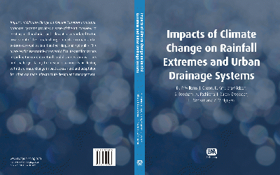
Some members of International Group on Urban Rainfall ([http://www.kuleuven.be/hydr/gurweb/index.html IGUR]) of IWA/IAHR Joint Committee on Urban Drainage[http://www.jcud.org/] has produced a book on the topic on the influence on climate and other forms of future change on extreme rainfall and the implications on urban drainage systems. | |||
In addition to a state-of-the-art overview of | |||
existing methodologies and relevant results related to the | |||
assessment of the climate change impacts on urban rainfall | |||
extremes as well as on urban hydrology and hydraulics, it contains a number of tutorials on how to use the described techniques in practice. One example is an easy-to-use tutorial on how to use [Category:WRF_Model|WRF model] on personal computers. This is a similar to -- but very much improved (therefore easier to use) -- the framework described in the article "[[Running WRF Model on Windows]]". [[The book on Climate Change, Extreme Rainfall and Urban Drainage|read more...]] | |||
==SWMM5-Python== | |||
[[file:QT4Agg_Swmm5_python.png|300px|right|thumb]] | |||
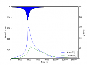
This is a python module for running SWMM5 model via python and extract results as python objects. [[SWMM5-Python|Read more..]] | |||
==IMHEN Report on Climte Change in Vietnam== | |||
(C) Institute of Meteorology, Hydrology and Environment (IMHEN), Vietnam. | |||
IMHEN conducted the project "Impact of climate change on water resources and adaptation measures" sponsored by the Government of the Kingdom of Denmark with the participation of consulting experts from the Danish Hydraulic Institute (DHI) and the participation of many Vietnamese agencies. [[Vietnam: Impact of climate change on water resources and adaptation measures|read more]] | |||
</div> | </div> | ||
---- | ---- | ||
|width="55%" class="MainPageBG" style="border: 1px solid #F0FFF0; color: #000; background-color: #F0FFF0"| | |width="55%" class="MainPageBG" style="border: 1px solid #F0FFF0; color: #000; background-color: #F0FFF0"| | ||
<div style="clear: right; text-align: left; float: right; padding: .4em .9em .9em" id="MainPageBox2"> | <div style="clear: right; text-align: left; float: right; padding: .4em .9em .9em" id="MainPageBox2"> | ||
==Webapps with python== | |||
=== | [[File:water-detect-webapp.png|center|thumb|center|500px|Interactive map, analysis and plotting tool for precipitation. [https://waterdetect.srv.pathirana.net/ LINK]]] | ||
[[ | |||
I | One of the surefire ways of creating co-ownership is to encourage co-discovery and co-design. For this, we face the challenge of bringing modern technological knowledge to the stakeholders, including communities, in an understandable way but yet allowing for them to interact and contribute in a meaningful sense. One of the modern tools that contribute to this mission is interactive web applications. They allow water managers and scientists to bring complex data analysis solutions, big-data technologies, dynamic water models closer to the non-specialist stakeholders in an appealing and simple-to-interact fashion. | ||
Here are some prototype web applications that were created for the water management, agriculture and asset management sectors. They are written in python using libraries like [https://plotly.com/dash/ Plotly dash] and [http://www.web2py.com/ web2py] to do the frontend. I use [https://auth0.com/blog/hosting-applications-using-digitalocean-and-dokku/ docker containers] based on [http://dokku.viewdocs.io/dokku/ dokku] -- [https://en.wikipedia.org/wiki/Platform_as_a_service a PaaS (Platform as a Service)] --to host these apps. | |||
[[Webapps with python|Read more..]] | |||
==Crowdsourcing groundwater quality in small islands== | |||
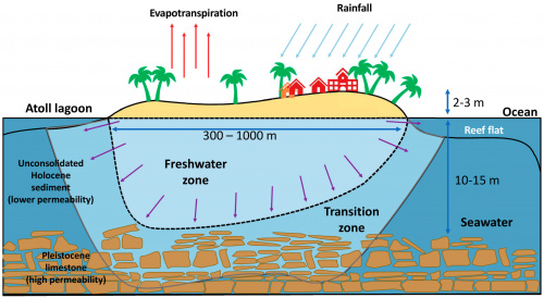
[[file:fresh_water_lens_xsection.jpg|thumb|500px]] | |||
The Maldives has more than 180 inhabited islands with many with populations less than 1000 inhabitants. Less populations do not mean they are facing lesser challenges to the sustainability or lower rate of change. In fact, these are among the most climate-vulnerable places on the earth and undergoing rapid change that need to be continuously monitored. But the challenge is every rufiyaa allocated for monitoring the vulnerability is money taken away from addressing the same vulnerability – a zero sum game. Therefore, in the Maldives, as well as other small islands, we need to continuously innovate on cost-effective, but also EFFECTIVE, ways of doing environmental monitoring. | |||
But can we enlist the help of the inhabitants of these islands to do the monitoring of the groundwater resources. This is exactly what we did with 45 inhabited islands. A simple idea: Every household that has a groundwater well (nearly 100% in many islands) is a potential sensor of the health of the freshwater lens. We just have to enlist their support and suddenly we have thousand sensors to monitor our resources! This is exactly what we did. We surveyed more than 2100 households from the 45 islands and inquired them how the perceive the groundwater they obtain from the family wells. Does it smell? Looks clear? Do they use it for drinking and cooking? Washing, bathing and toilet flushing? We went on. The result was a dataset that revealed plenty of useful information. [[Crowdsourcing groundwater quality in small islands|Read more ...]] | |||
==Urbanization not only heats up the cities, but could increase extreme rainfall== | |||
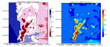
[[File:heat_maps.png|thumb|450px|Latent heat and sensible heat flux maps for Mumbai (Simulation)]] | |||
On 21 July 1999, Nerima-ku region of Tokyo received an unprecedented 111 mm of rainfall in one hour! Later studies lead to the conclusion that this heavy rainfall development was aided by urban heating due to the [[wikipedia:urban heat island|urban heat island]] effect of the Tokyo city. | |||
With the cities in the world increasing in size at a phenomenal rate, the question whether larger urban footprints could enhance extreme rainfall is no longer solely an academic one. [[Urbanization not only heats up the cities, but could increase extreme rainfall.|Read more..]] | |||
==Using Wiki in Higher-Education: Application in organizing research groups== | |||
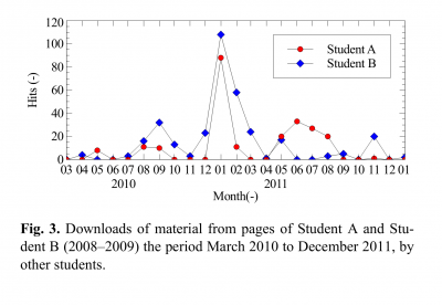
[[File:Wiki_in_edu_fig_2.png|thumb|400px|left|]] | |||
This is a natural extension of the story of this web site. I started this web site in 2006 [[How this site works|hacking MediaWiki software]]. That was just before I moved from Japan to Netherlands and started working at UNESCO-IHE. From the end of 2006, I used the same contraption to support my research group at UNESCO-IHE (which consisted of five six masters students every year, myself and one or two other faculty members). The experiment completed its fifth year in 2011. I was thinking this is the time to document the experience when I came to know that [http://www.hydrol-earth-syst-sci.net/| Hydrology and Earth System Sciences Journal] is publishing [http://www.hydrol-earth-syst-sci-discuss.net/special_issue72.html special issue on Hydrology education in a changing world]]. Recently the article finished the review cycle and was published in HESS. [[Using Wiki in Higher-Education: Application in organizing research groups|Read More ...]] | |||
==Improving Drinking Water Quality without Compromising Long-term Safety== | |||
Treating water with chlorine is a time-tested way of ensuring biological safety of drinking water. However, excessive chlorination creates chlorination by-products, that are known to cause long-term risk of cancer. We attempted to make a safe compromise. | |||
We integrated EPANET2.0 (a steady-stage, demand-driven water distribution network model), a particle back-tracking algorithm (can trace the origin of water delivered at any demand point in the network), chlorine and disinfection by product model and a multi-objective optimization algorithm to enable computing the optimal water treatment, minimizing long-term chemical risk (represented as cancer treatment cost.) [[Improving Drinking Water Quality without Compromising Long-term Safety|Read more...]] | |||
==Ecosystem value of SuDS== | |||
We analyse the implementation of Sustainable Drainage Systems (SuDS) as a solution to better | |||
manage storm water runoffs and reduce urban flooding, and at the same time provide significant | |||
Ecosystem Services (ES). ES vary from temperature control at urban and building scale to ma in water | |||
savings, depending on the type of SuDS considered. [[Ecosystem benefits of SuDS|read more]] | |||
</div> | </div> | ||
Latest revision as of 08:40, 21 March 2022
Random musings on various topics: Climate and water security, Small Island Developing States (SIDS), IT tools, Computer programming and Web-Applications, Citizen Science, ... Views are personal!
Systems thinking for Urban Water SystemsBy Dr. Mohanasundar Radhakrishnan What is lost in an urban water system? The answer is obvious when you look at what flows in and out of these urban water networks, it is water. Some might say money and some might say energy. Yes, this is true but is not the whole truth. This training is about finding out what is lost from an urban water system by looking beyond water and looking in the urban systems to track the lost water and the other elements that are being lost. The training touches upon the three prime movers of the urban water utility, namely engineering, management and strategic planning. The place, proportion and play of this trinity in an urban water utility can be ascertained only by a thorough understanding of the urban system that is served by the water utility. This can shed light on what is actually gained and lost through urban water systems. We the engineers and managers of urban water utilities are trained to ascertain the problem, quantify the impact, find out why it happened and devise ways to minimise or eliminate the problem. Quantification has always been the guiding principle, the means and the end in this endeavour. The water balance methods in their original or modified form used all over the world follow this logic and has proved to be a success in estimating the quantity of non-revenue water and formulating actions to reduce the losses in terms of water and revenue. The training starts by introducing the conventional water loss assessment methods to the urban water engineers and managers; the various elements of a water distribution system comprising physical, conceptual and design aspects; and, water loss management measures. Understanding and analysing these engineering aspects of the water supply system would create a comfort zone from which the engineer can start the process of identifying and minimising losses. Read more ...
Climate Security of Small IslandsClimate change presents unique challenges to Small Island Developing States (SIDS). The difficulties that all countries face in effectively coping with climate change impacts are exacerbated in SIDS because of their small geographical area, isolation and exposure. The associated development challenges from sea-level rise, altered rainfall patterns, and storm-surges threaten to reverse progress made towards the Millennium Development Goals now and in the future. The United Nations Development Programme (UNDP) provides on-the-ground support for small island and low-lying countries at the global, regional and national scales. - UNDP The Maldives is already facing the brunt of Climate Change in the guise of water scarcity. Small atoll islands' water security depend on the important, but highly climate-sensitive, fresh water lenses. Read more ...
Urban adaptation in rapidly growing cities need a paradigm shiftWe have been working with rapid developing cities like Can Tho, vietnam (see our work) regarding adaptation. Here we intentionally use the term "Urban Adaptation" instead of more common "Climate Adaptation". The reason for that is, in cities like Can Tho (or any other Secondary City in the Global South - SCGS), climate change -- while being extremely relevant and important -- is only one of many pressures that they have to deal with in adaptation; Land-cover change, rapid population increase, increasing pollution are some others. In these two part series, we argue the importance of changing the way we look at urban adaptation in SCGS. Simply put, we are in a context that is a combination of high urgency and high uncertainty. But, we still use 'predictive' planning approaches that works well only in contexts of good predictability and less uncertainty. While there are multiple reasons (historical, cultural, economic) for this, it is important to start the discussion on how to change that to a more 'adaptive' -- or as we call it 'agile' approach. That is the story of these two articles. read more... Capturing the changing dynamics between governmental actions across plausible future scenarios in urban water systemsThis paper puts forth a systematic approach to select the governmental actions that can ensure water quality based on the connection between governmental actions at present and in the future using Systems approach (Von Bertalanffy, 1968), SWOT analysis (Houben et al., 1999) and DPSIR framework (OECD, 2003). The proposed methodology under the ambit of systems approach employs: (i) SWOT analysis to identify the connections; and, (ii) DPSIR framework to quantify the connections using impact based indicators for connections between actions. The methodology has been tested using six governmental actions across four plausible future scenarios in Luzhi Town, a unique water village within Suzhou city, China. read more... The book on Climate Change, Extreme Rainfall and Urban DrainageSome members of International Group on Urban Rainfall (IGUR) of IWA/IAHR Joint Committee on Urban Drainage[1] has produced a book on the topic on the influence on climate and other forms of future change on extreme rainfall and the implications on urban drainage systems. In addition to a state-of-the-art overview of existing methodologies and relevant results related to the assessment of the climate change impacts on urban rainfall extremes as well as on urban hydrology and hydraulics, it contains a number of tutorials on how to use the described techniques in practice. One example is an easy-to-use tutorial on how to use [Category:WRF_Model|WRF model] on personal computers. This is a similar to -- but very much improved (therefore easier to use) -- the framework described in the article "Running WRF Model on Windows". read more... SWMM5-PythonThis is a python module for running SWMM5 model via python and extract results as python objects. Read more.. IMHEN Report on Climte Change in Vietnam(C) Institute of Meteorology, Hydrology and Environment (IMHEN), Vietnam. IMHEN conducted the project "Impact of climate change on water resources and adaptation measures" sponsored by the Government of the Kingdom of Denmark with the participation of consulting experts from the Danish Hydraulic Institute (DHI) and the participation of many Vietnamese agencies. read more
|
Webapps with python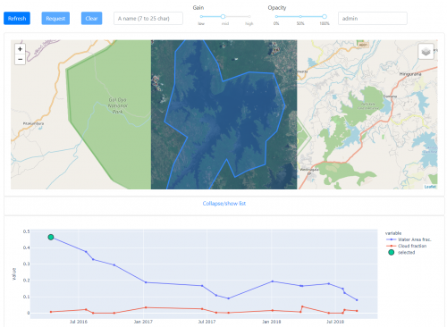 Interactive map, analysis and plotting tool for precipitation. LINK One of the surefire ways of creating co-ownership is to encourage co-discovery and co-design. For this, we face the challenge of bringing modern technological knowledge to the stakeholders, including communities, in an understandable way but yet allowing for them to interact and contribute in a meaningful sense. One of the modern tools that contribute to this mission is interactive web applications. They allow water managers and scientists to bring complex data analysis solutions, big-data technologies, dynamic water models closer to the non-specialist stakeholders in an appealing and simple-to-interact fashion. Here are some prototype web applications that were created for the water management, agriculture and asset management sectors. They are written in python using libraries like Plotly dash and web2py to do the frontend. I use docker containers based on dokku -- a PaaS (Platform as a Service) --to host these apps. Read more..
Crowdsourcing groundwater quality in small islandsThe Maldives has more than 180 inhabited islands with many with populations less than 1000 inhabitants. Less populations do not mean they are facing lesser challenges to the sustainability or lower rate of change. In fact, these are among the most climate-vulnerable places on the earth and undergoing rapid change that need to be continuously monitored. But the challenge is every rufiyaa allocated for monitoring the vulnerability is money taken away from addressing the same vulnerability – a zero sum game. Therefore, in the Maldives, as well as other small islands, we need to continuously innovate on cost-effective, but also EFFECTIVE, ways of doing environmental monitoring. But can we enlist the help of the inhabitants of these islands to do the monitoring of the groundwater resources. This is exactly what we did with 45 inhabited islands. A simple idea: Every household that has a groundwater well (nearly 100% in many islands) is a potential sensor of the health of the freshwater lens. We just have to enlist their support and suddenly we have thousand sensors to monitor our resources! This is exactly what we did. We surveyed more than 2100 households from the 45 islands and inquired them how the perceive the groundwater they obtain from the family wells. Does it smell? Looks clear? Do they use it for drinking and cooking? Washing, bathing and toilet flushing? We went on. The result was a dataset that revealed plenty of useful information. Read more ... Urbanization not only heats up the cities, but could increase extreme rainfallOn 21 July 1999, Nerima-ku region of Tokyo received an unprecedented 111 mm of rainfall in one hour! Later studies lead to the conclusion that this heavy rainfall development was aided by urban heating due to the urban heat island effect of the Tokyo city. With the cities in the world increasing in size at a phenomenal rate, the question whether larger urban footprints could enhance extreme rainfall is no longer solely an academic one. Read more..
Using Wiki in Higher-Education: Application in organizing research groupsThis is a natural extension of the story of this web site. I started this web site in 2006 hacking MediaWiki software. That was just before I moved from Japan to Netherlands and started working at UNESCO-IHE. From the end of 2006, I used the same contraption to support my research group at UNESCO-IHE (which consisted of five six masters students every year, myself and one or two other faculty members). The experiment completed its fifth year in 2011. I was thinking this is the time to document the experience when I came to know that Hydrology and Earth System Sciences Journal is publishing special issue on Hydrology education in a changing world]. Recently the article finished the review cycle and was published in HESS. Read More ... Improving Drinking Water Quality without Compromising Long-term SafetyTreating water with chlorine is a time-tested way of ensuring biological safety of drinking water. However, excessive chlorination creates chlorination by-products, that are known to cause long-term risk of cancer. We attempted to make a safe compromise. We integrated EPANET2.0 (a steady-stage, demand-driven water distribution network model), a particle back-tracking algorithm (can trace the origin of water delivered at any demand point in the network), chlorine and disinfection by product model and a multi-objective optimization algorithm to enable computing the optimal water treatment, minimizing long-term chemical risk (represented as cancer treatment cost.) Read more... Ecosystem value of SuDSWe analyse the implementation of Sustainable Drainage Systems (SuDS) as a solution to better manage storm water runoffs and reduce urban flooding, and at the same time provide significant Ecosystem Services (ES). ES vary from temperature control at urban and building scale to ma in water savings, depending on the type of SuDS considered. read more |
